Wat Phra That Bang Phuan in Nong Khai's Ban Don Mu 'village', Phra That Bang Phuan district is one of the region’s most a beautiful Indian-style stupa and one of the most sacred sites within the province.
It is believed, that some of Lord Buddha’s bones are buried here.
Therefore the place is much respected and worshiped by residents and visitors alike.
Although no one really knows, when the first chedi of Phra That Bang Phuan was built, it is assumed, that it is of the same age as the chedi in Phra Phathom, as it is similar in construction (built with bricks) and style.
In 1559 King Sayaxettha of Chanthaburi (Viang Chan – aka Vientiane, Laos) extended his capital across the Mekong river and built a taller Lao-style chedi over the original as a demonstration of faith.
The nearby Naga pond or 'Sa Phaya Nak' was used in the past to bath the new rulers as an auspicious gesture.
However, heavy rain caused the chedi in 1970 to collapse. Thailand's Fine Arts Department restored the structure in 1976 and 1977.
The current chedi stands 34.25m high and has several older chedis around it. The lower base of the chedi is 17.2 m wide and consists of five tiers.
This special setting gives the temple of Phra That Bang Phuan an ancient and sacred atmosphere.
Wat Phra That Bang Phuan is 23 km outside Nong Khai direction to Tha Bo.
This Blog will inform and tell stories about Thailand's Isaan as well as Laos, its people, culture, religion and the Mekong River...
Tuesday, June 29, 2010
Tuesday, June 22, 2010
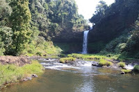
Waterfalls on the Bolaven Plateau
The Bolaven Plateau is an elevated region in Southern Laos Champassak province. The elevation ranges from about 1'000 to 1'350 meters above sea level.
The plateau is a reach cultural and agricultural area, crossed by several rivers and scenic waterfalls.
The name of the plateau 'Bolaven' refers to one of its ethnic group which have dominated the region: the Laven. However, migrations by the majority Lao ethnic group has modified the ethnic composition of the region. Other ethnic groups in the Bolaven Plateau are the Alak, Katu, Ta Oy, and Suay.
Nowadays the Bolaven plateau is an important agricultural area which produces one of the best coffee in the world. Another important factor is tourism, which greatly contributes to the regions growth. Lastly, bauxite mining is increasingly becoming more important as well.
Tad E Tu Waterfall
Tad E Tu Waterfall is located between Pakse and Paksong at KM 35. The waterfall can be reached over a small and steam path and stairs. The small pool at its bottom invites with some refreshing swimming opportunities.
Tad Champee Waterfall
Tad Champee Waterfall is located between Pakse and Paksong at KM 38, opposite Tad Fane waterfall. The waterfall is about 3 kilometers from the main road. The Tad Champee consists of one single cascade. Its pool is offering some refreshing bath...
The Tad Fane Waterfall
The Tad Fane Waterfall is 38 KM outside of Pakse and probably the biggest twin waterfall in the Bolaven region. The water dropps over 100 meters!. The best view on this waterfall one gets from the nearby view point at Tad Fane Resort, a friendly lodge overlooking the gorge of the Tad Fane waterfall and nestled within some tense vegetation. For a closer look a small walk of 15 minutes is required to reach the bottom of the falls.
Tad Yuang Waterfall
Tad Yuang Waterfall is a bit further along the way to Paksong at KM 39. This waterfalls comes with a nice pick nick area at the top of the waterfall. A view point at the top allows a great panorama over the whole waterfall.
Tad Phasuam Waterfall
Tad Phasuam Waterfall is on the way to Tad Lo in Salavan province, after leaving Pakse turn left at KM 21 and continue for a further 15km. Tad Phasuam Waterfall is a beautiful cascade in a U form. There is a small cultural village nearby.
Labels:
Bolaven Plateau,
Laos,
Tad Champee,
Tad E Tu,
Tad Fane,
Tad Phasuam,
Tad Yuang
Friday, June 18, 2010
Uncharted land - caves, monks and Khmu
On my last visit in Luang Prabang I had the opportunity to visit an "unknown" cave. Tham Khou Pa. The monks used to live in that cave 10 years ago. There are rumors, that the monks engaged with local village girls. So the government ordered them to leave the place. Since then the place is deserted.
The cave, the mountain, the rice paddies and the whole area are very pristine and preserved.
The foot of the mountain is surrounded by a agricultural land mainly used to grow rice. A small path leads along and finally through the paddies for about 200 to 250 meters before it reaches the slop which ascends in a 45 degree angle to the top of the mountain. The path continues to some small bush vegetation and a small mountain side field, containing all kind of crops, such as bananas, pineapple, maize, cassava and other eatable plants. The garden is owned by a Khmu family.
We met the 80 years old grandfather of the family who finally showed us the way to the cave. As our first attempt, lead by a local guide was unsuccessful.
The old man met us at the rock cliffs where we were waiting for him, soaked in our on sweat. The last part just before the slop ends and goes over in a rocky, more mountainous area, the trail was overgrown with grass and bamboo. We used some knives which we broth along for the purpose to make our own path.
I consider myself as a more sportive person, but compared to the old Khmu I had not the slightest chances of keeping pace with him. In fact I lost him after 3 minutes. He even overtook our own 25 year old Lao guide. The old guy was sitting in front of the cave, smiling and waiting for us. While the rest lost another liter of body fluid... I was quite a bit impressed of the old Khmu guys fitness. Well, more than 65 years of gardening on the mountain seems to make one stronger... Some small parts included minor climbing skills.
The cave itself is very interesting and one can see that it has been left for a long time. Some wooden and bamboo structures built by the monks still remain intact, though the time takes its tribute.
Natural light and ventilation make the cave quite a livable place. The cave consists of an small entrance area and one big chamber with some smaller hideaways, which were used by the monks as sleeping area.
All in all a very nice, interesting and "undiscovered" cave, just a few minutes from Nam Khan.
Needless to say that I had to refill my missing body fluids with a couple of beerlaos afterwards.
Monday, June 7, 2010
Trail of Falls and Tad See, Luang Prabang
I had recently the opportunity to survey a trekking tour in Luang Prabang – the Trail of Falls. The trek leads through lush vegetation, Teak wood, pineapple and banana plantations and some smaller batches of primary forest. Some watch towers along the way allow an excellent view and make some pictures of the magnificent mountainous country side near Luang Prabang.
The first part of the trek can either be done of an elephant's back or on foot. The path is very easy and uncomplicated. The walk can be done in about 1,5 hours.
Short after my arrival in the Elephants Village hospice camp lunch was served.
The Trail of Fall starts here and follows through a small valley, tensely covered with primary forest. Different species of trees and other plants can be observed.
Guides informed me about medicinal and eatable plants. Insects and few birds can be seen. Small ponds with pristine and crystal clear water are home to small fishes and river crabs.
Although during the dry season the Trail of Falls becomes more like a Trail of Ponds, however from the end of the rainy season until mid or end of February a myriad of falls, ponds, small islands, and caves appear and form one of the most beautiful landscapes one can imagine.
The Trail of Falls is a bit more demanding than the first stretch. Average fit person should be able to walk the trail within 1,5 to maximum two hours. Some stairs and railings have been made to facilitate the walk over some small batches of more difficult terrain. In general also this Trail is easy.
Towards the end of the Trail of Falls Tad See waterfall and its many cascades come into sight. Tad See water fall is very beautiful during May to February.
A construction made by some Thai engineers is doing a good job in getting water to the fall and filling the pond at its end with enough water all year round. Although the pipes and the sand bags used to dam the water are not particularly beautiful.
All in all a wonderful trekking tour out of Luang Prabang, which I can recommend without hesitation to any nature lover.
Subscribe to:
Posts (Atom)